
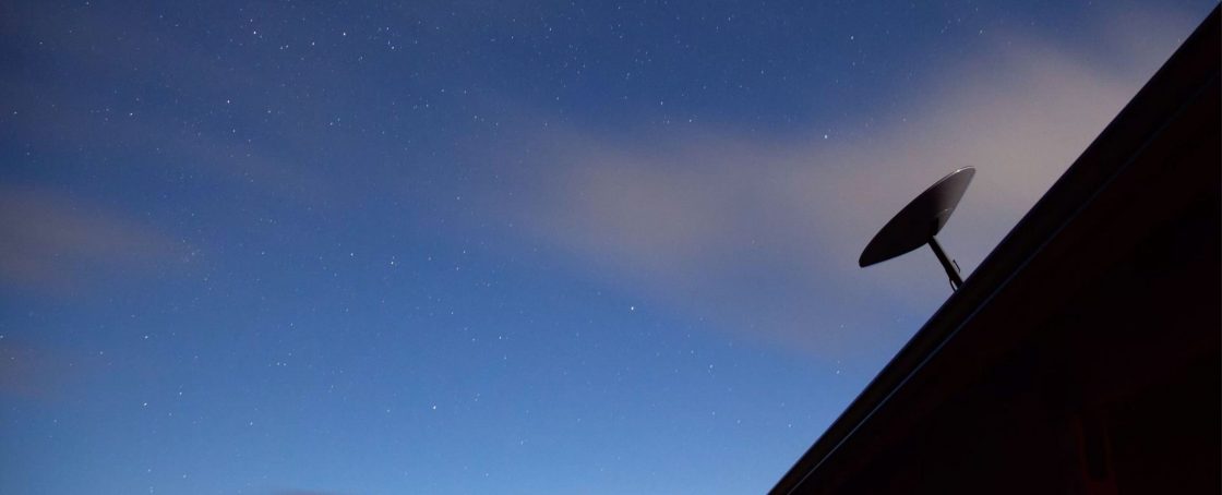
When a snapshot of a mirrored monolith was posted by state biologists conducting a survey on local bighorn sheep in November 2020, it ignited what would soon become one of the most intensive open-source pursuits for topological intelligence the world has ever seen.
Within hours, thousands of amateur sleuths were dissecting the image (which was captured from a helicopter), relying heavily on satellite intelligence shared through social media channels to track down the exact coordinates of the mysterious object. In the end, it took Reddit users less than four days to locate the exact coordinates of the monolith with the help of Google Earth. And it turned out to be a piece of art.
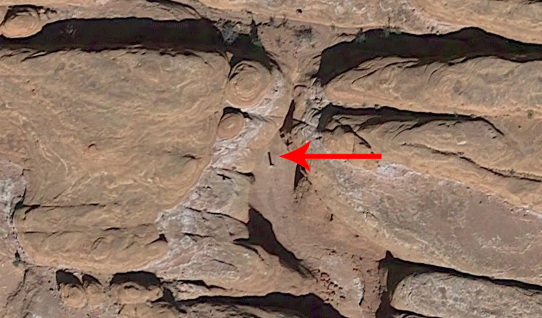
The exercise demonstrated the power of what can be achieved with broad and cheap public access to satellite imagery. Consequently, it also highlights the reach of the global panopticon that is life today.
The background
Since reconnaissance satellites were first introduced in 1959 with the American CORONA satellite program, access to real-time images they take has remained mostly in the hands of a privileged few e.g. government officials, the military, hedge funds, and private intelligence firms. This, however, is no longer the case. As of the 2020s, the diminishing cost of satellite imagery access by the public, albeit still latent, is having a huge democratising effect on the industry.
One need only look at the thousands of open-source intelligence “reporters” (many of them amateurs) tracking the Russian/Ukraine war to see the impact this access has had. Who didn’t see the satellite images of the 40km-long Russian military convoy north of Kyiv in March 2022, for instance?
Ever wonder how an anonymous account on Twitter or Telegram gets access to those “nearly live” images in the first place? Or how they can afford to distribute them cost-effectively for free?
We did too.
Chances are that much of the distribution has less to do with cheap public access to satellite imagery and much more to do with useful connections to those with already established access.
Even so, over the last few years, market conditions and technological innovation have created extremely profitable grounds for the mass-market expansion of the satellite industry. City analysts expect the launch cost bottleneck – with the average launch costing anywhere between $10 million to $400 million, depending on the launch vehicle – to be brought down 95 per cent by 2040. Once this happens, the space industry could reach an estimated $1tn in annual revenue. These expectations have wooed substantial amounts of private sector investment, with space infrastructure companies receiving an estimated $14.5bn of private investment in 2021.
The longer-term side effects of mass satellite access, however, are less well understood. Some fear they could have profound consequences on how economies manage themselves, notably by driving commercial activity into satellite “dark spaces” in a bid to maintain privacy and information advantage. In many cases, this may already be happening.
A good example is the sudden dispersal of that Russian convoy, referenced above, mostly under the cover of nearby forests, as soon as reports about it went viral.
The ability for offensive columns to go entirely unnoticed, of course, was considered miraculous even during the German assaults of 1940. With today’s satellite technologies, however, the possibility of launching a successful sneak attack is virtually nil.
Now satellite transparency is going even further thanks to the development of technologies such as LiDAR or Synthetic Aperture Radar, whose beams allow satellites to penetrate thick forest canopies or even “see-through” buildings. While most of these technologies were developed in the mid-to-late 20th century (the first SAR satellite, operated by Jet Propulsion Laboratories and NASA, was used in 1978), their commercial use has only truly flourished in the past decade.
The topography of the satellite industry
By the end of 2020, the Satellite Industry Association estimated the number of satellites circling the earth had increased by 17 per cent in just that year alone, with 386 satellites bringing the total number of these lonely orbiters to 2460.
These estimates will continue to multiply. In January 2021, a single SpaceX rocket launched 143 nanosatellites into space. Hardly a surprise then that the private sector now accounts for a whopping 75 per cent of the global space business.
For now, the space-based visual intelligence market can be broadly sectioned into three closely interrelated divisions: the manufacturers, the operators, and the analytics companies.
Some firms, such as Israeli manufacturer Elbit Systems, have more specialised offerings. These include the cutting-edge Intelligence, Surveillance and Reconnaissance (ISR) space-based platform as well as the highly advanced commercial communications satellite called NANOVA.
Owing to the nascent nature of the space market, however, the most significant players sit across several of these roles. The public sector’s footprints can be found across almost all of them too.
Towards the higher end of the spectrum, Airbus Intelligence, which recently secured an extension on its contract to provide the British Royal Navy with satellite-based maritime surveillance services, manufactures and operates its own proprietary Pleiades Neo satellite constellation.
This constellation of optical satellites is composed of four identical platforms that use two orbital planes, enabling Pleiades two location revisits per day. Their expensive data capture, visualisation, and analysis services are presented relatively raw. The Royal Navy analysts then have the ability to conduct their own layer of analysis on Pleiades’ imagery and sensor data.
Other key players, meanwhile, are explicitly specialised for commercial intelligence purposes, such as geospatial insure-tech firm McKenzie Intelligence Services (MIS), which partnered with Lloyds in 2021. These developed the Global Earth Observer (GEO) platform together with the European Space Agency for the insurance industry.
Understanding that most commercial clients prefer their data digested, McKenzie’s platform offers Lloyds clients “real-time analysis of global perils, including storms, wildfires and flooding (…) assessing damage to insured infrastructure and businesses”. However, MIS also operates at least three MIS-branded satellites directly. These offer mission-specific goals to more specialised clients (for a pretty penny of course).
More broadly, there is also a proliferation of smaller and more specialised satellite data analytics firms. For instance, HawkEye360 uses Radio Frequency (RF) signal location data gathered by their three small satellites, “Cluster3”, which allows clients to determine the accurate location of a given radio frequency.
This RF intelligence has enabled the firm to produce evidence which claimed that many Chinese-owned fishing ships were disabling their GPS-based Automatic Identification System (AIS), commonly known as transponders, to conduct ‘dark’ fishing in the protected Galapagos waters.
Specialisation is emerging
It is probably not surprising that this dramatic shift has enabled some amazing specialisms to emerge, especially concerning mass provision.
These include something called micro-satellite orbital transportation, currently being brought to market by Italy’s D-Orbit. D-Orbit’s brilliant solution is to launch what could be considered “space trucks” containing several micro-satellites each. D-Orbit pays for the launch and the manufacturing of the satellites, which can then be sold or rented out to clients pre- or post-launch. Their not-so-little space truck plods along the desired orbital path to launch their client’s satellite with promises in the future that it will be able to retrieve these too.
Are you worried your prospective partner, who your friends nickname Shifty Gerrard, is exaggerating the speed of mineral extraction in his Zambian mine? Worry not, Shifty Gerrard now has the means to recruit a company like Airbus Intelligence to calculate the volume of his mine’s extracted material – to the kilogram – based on visual imagery.
Data sourced in these ways is more prevalent than you would expect, even in the world of finance. Indeed, counting vehicles parked outside store parking lots can be used to gauge estimates of sales figures. Realising this, Associate Professor Panos Patatoukas, together with the Fisher Center for Business Analytics, collected 4.8mn images of parking lots at 67,000 individual stores across the United States. They concluded that “the informational advantage yields 4 per cent to 5 per cent in the three days around quarterly earnings announcements”. Even from as early as 2016, Orbital Insight, a satellite imagery procurer, counts seventy hedge funds amongst their clientele.
Then there are the satellite data middlemen. They harvest and treat primary data from satellite companies to make it viable for use in the commercial landscape or mass market. These are cropping up faster than crypto-fund meltdowns. For instance, Israeli intelligence and AI data analysis company, Windward, has partnered with HawkEye360 to provide maritime intelligence solutions to the global maritime industry.
Some organisations simply purchase, clean, and mesh satellite imagery and offer it free-of-charge online such as Google Earth or Zoom Earth. It is vital to note how their open-source nature has transformed these free services into critical intelligence tools.
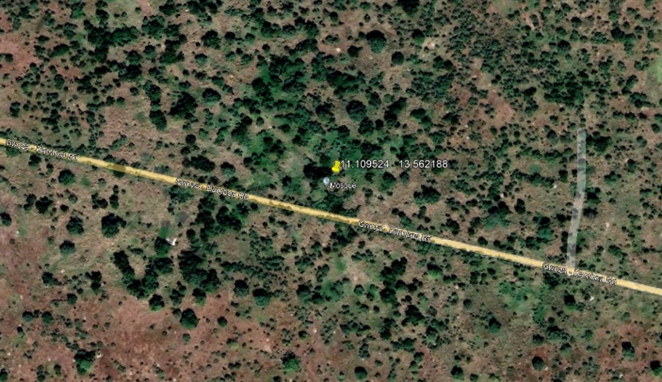
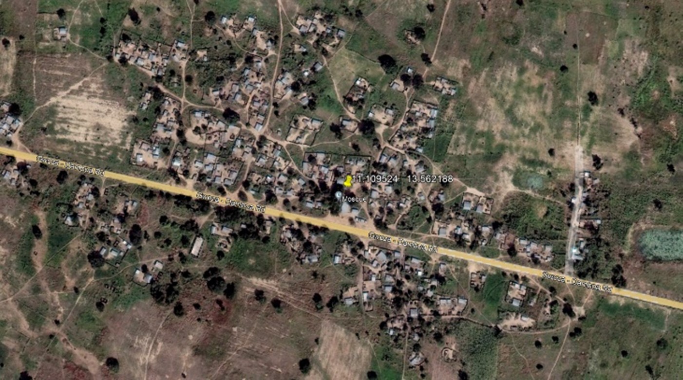
The desktop version of Google Earth – Google Earth Pro – allows for time-lapsed satellite imagery typically taken every few months or years. Furthermore, community plug-ins for such services allow the sharing of points of interest, as well as the cycling of different satellite feeds. Such examples can be participatory; if you were to navigate to latitude 11.109524 and longitude 13.562188 and scroll between images taken in February 2014 and November 2018, you would see an entire Congolese village disappear into the undergrowth, victim to the regions’ internecine conflict.
It’s not quite a cottage industry yet, but it’s not far off.
The emergence of a counter-detection industry
For every action, there is an equal and opposite reaction. This applies to the satellite industry as much as any other. Investors in the space should remain mindful of that.
What’s more, as promising and expansive as these satellite proliferation developments are, those investing in the industry are yet to really pick up on the risks associated with over-adoption.
Most market analyses that inform investors ignore how these trends could impact social norms, preferring to focus on the purely commercial implications and opportunities offered by such new services.
What happens, however, when anyone can spot an enemy state’s secret nuclear sites under development from their gas-heated trailers in Nebraska? Chances are it will immediately trigger hundreds of visual intelligence analysts in equivalent military departments worldwide to start developing counter-detection techniques.
As an example of reactionary trends, Janes reports this week about Saab’s new Barracuda camouflage tech, which is designed to protect soldiers from detection by thermal imaging sensors, following the proliferation of “airborne thermal sensors” across the modern battleground, capable of detecting “unprotected soldiers”.
In a global panopticon system, the returns from such invisibility or from duping satellites and drones are only going to increase as the years go by. As counter-detection technologies become ever more sophisticated and accessible, trust in satellite imagery may experience its own post-truth moment as a result too.
In the commercial sector, these sorts of evasive and manipulative practices are nothing new. Gold bullion custodians have long had to handle concerns that the precious gold bars they look after have actually been pilfered and swapped for much cheaper tungsten bars cleverly disguised as gold.
There is similarly nothing stopping Shifty Gerrard from purposefully trying to dupe satellites with camouflage techniques either.
A miner has, for example, the capacity to disguise the rubble he extracts from the ground by shrouding it with a thin layer of a more precious material. While satellites can detect heat and lifeforms, only the most sophisticated and expensive sensors may be enough to run Star-Trek-style diagnostics of specific bundles of commodities.
Even now in most cases, on-the-ground, open-source or human intelligence methods are still necessary to comprehend what exactly is going on. That means satellite imagery may already be creating a false sense of security. Indeed, perhaps by virtue of experience, military visual intelligence units are often structurally placed parallel to respective signal intelligence units. In this way, both units’ analyses can be fed to the same destination, where the combined intelligence can be cross-referenced to reach a more accurate conclusion.
A failure to take the big picture into account, or to overly presume x is y rather than z, can lead to mistakes, possibly even tragedies. Colin Powell’s famous weapons of mass destruction speech in 2003 at the United Nations used satellite imagery in trying to prove Saddam’s regime was hiding such weapons. These images ostensibly identified active chemical munitions bunkers among other potential sites of interest. This, of course, turned out to be incorrect.
A perfect information paradox
Studies into how financial markets have coped with ever-increasing transparency provide good insight into how counter-satellite detection technologies may evolve and impact the industry over the medium term.
According to the Grossman-Stiglitz Paradox, which argues that perfect informationally efficient markets are impossible, the race towards perfect visual information will always open a pathway to its own demise.
The logic here is that if prices perfectly reflect available information, there will be no profit to be had from gathering information. And if there’s no profit to be had from gathering information, nobody will expend resources doing it, and the market for satellite imagery (or, in the case of Grossman-Stiglitz, information gathering in general) will collapse – opening the door to information asymmetry and opacity again.
The law of diminishing marginal returns, meanwhile, predicts that after some level of optimal capacity is reached, additional factors of production will result in smaller output increases.
It seems inevitable that the over-proliferation of satellite operators and data analysts will lead to reactionary consequences, likely both regulatory and practical, that could affect the use of such data for commercial intelligence purposes.
The question of how close we are to the main thrust of the counter-reaction remains crucial to the investors of the space industry.
Consider Sentinel Playground, an open-source satellite data aggregator, which merges a variety of satellite feeds, allowing users to see almost daily satellite images of the same area.
How long before this technology triggers its first crime of passion, courtesy of a suspicious partner detecting the same red Corolla being parked outside of the house of their best mate every other day?
The days of engaging a private eye to hang around a suspected mistress’ house in a Ford Escort with a long lens and a packed lunch are no longer necessary.
On the flip side, consider the use of satellite technology by would-be cat burglars to better track and monitor the whereabouts of residents so that houses can be broken into without fear of being disturbed. Indeed, some archived satellite imagery middlemen, who purchase existing satellite imagery from satellite providers, already offer extremely competitive pricing – the worryingly named SpyMeSat Web’s prices go from $ 4 to $ 1,599. However, Joe Bloggs could also task a $12 per kilometre high-resolution image from SkyWatch, or even select the most up-to-date satellite imagery of any area of the world with the free Spectator.Earth service.
If such stories were to be popularised widely in the Daily Mail, precautionary actions would be taken alongside calls for regulatory intervention.
Dumb intelligence
Satellite imagery, especially the open-source type, is currently extensively used in the private intelligence industry. And not just for tracking down affairs.
The technology, especially when used in conjunction with the visual tracing of images posted on social media, can be crucial when identifying hidden assets (typically in tropical paradises.)
These resources can help agencies establish facts in the fight against illicit and illegal trade.
For example, the warehousing requirements of certain highly regulated sectors, such as the refrigerants industry, mean stock such as ISO tanks are often too large to be stored indoors. This could allow for an orbital calculation of a certain seller’s visible stock matched against estimated quota figures. Though such use is currently very much on a case-by-case basis, the sector’s continual expansion of increasingly cheap and accessible services means it is only a matter of time before such visual intelligence methods are part-and-parcel of anti-illicit trade methodologies.
It is no surprise that many of the recently emerging firms, especially those of a small and specialised nature, have chosen to focus on data analytics. It’s well worth noting the Virginia-based HawkEye presents itself as a “Radio Frequency data analytics company” (my emphasis).
However, not many are aware of the (currently limited) political implications of satellite data proliferation with regard to the public.
The more effectively extensive satellite imagery is used, the more visual intelligence targets will take active steps to camouflage their orbital vulnerabilities. Possibly using 21st-century equivalents of Operation Fortitude when the Allies’ successful efforts to camouflage the real landing zone for D-Day by covering ISO tank storage areas to look like piles of wooden pallets. As ever, the criminal networks will likely be the most pioneering in this field.
But it’s on the regulatory front that the biggest risk to operators lies.
If the public and commerce are increasingly upended by too much satellite intrusion, we may see calls to limit access or regulate it intensively.
When faced with technological innovation, American or British privacy laws regarding surveillance generally come down to whether an individual’s “reasonable expectation of privacy” has been violated. Though a drone snooping through your house is a clear violation, what of a satellite orbiting hundreds of miles up, with a 15cm resolution, that could eventually know what type of latte you overspent on at Starbucks? Currently, regulations are shifting in the opposite direction – the United States granted landmark permissions to DigitalGlobe to sell imagery at a 0.25-metre resolution in August 2013.
This invites the question of what sort of incident might trigger an existentially threatening regulatory response.
Arguably, it wasn’t until the issue of ‘fake news’ became preponderant post-2015 that the Western world awoke to the political implications of too much data availability in the more conventional media space.
There are inklings of similar goings-on already.
Consider the stories on the internet about Direct Energy Weapons (DEWs) and their supposed relationship to the Californian wildfires from 2017 onwards. DEWs are ranged weapons that concentrate beams of energy, typically lasers, microwaves, particle or sound beams, on a specific target. Though the concept has existed for almost a century, lasers being formerly termed “death rays” during the 1930s, it is only recently that the US military, through its Space Force, has announced it is seeking to develop such platforms in orbit.
However, several news stories ranging from the “Havana Syndrome” events, or the mysterious directed energy attack near the White House in 2021, suggest such systems are already in use. The conspiracy-o-sphere, therefore, believes such weapons are used for obscure political purposes – notably, in causing the California wildfires.
In a bid to persuade the public of their theory, those pushing the narrative have even turned to open-source services such as NEXLAB’s Satellite and Radar Weather feeds to assert the alleged visibility of DEW beams from space.
On the flip side, the most high-resolution map of Antarctica released in 2018 by NASA is one of the few ways of retrieving good, non-patchy satellite images of the South Pole. A comparatively low amount of available high-resolution satellite imagery over Antarctica, however, has led to conspiracy circles regularly pondering what’s “really” going on in the icy landmass.
Some of the more well-plugged members of such groups have discerned a way of using CIMSS’s Morphed Integrated Microwave Imagery satellites in their attempt to prove that mysterious energy waves are beamed from Princess Elisabeth Station in the South Pole to affect weather patterns. Whether these groups have discerned something worrying or not (the latter being more likely), it shows how even satellite imagery can become politicised, and deployed by fringe groups for political purposes to spin elaborate narratives or hoaxes.
Offsetting the above are positive players in the open-source space like Forensic Architecture, a multidisciplinary research group in Goldsmiths, who have been using satellite technology together with advanced architectural and open-source research to document communities affected by state violence.
Is consolidation coming?
Proliferation more often than not leads to consolidation. In a market so impacted by public sector use, much like in the arms industry, this will likely orientate around those companies (like Airbus Intelligence) that maintain a consistent core of public clients, or around firms whose data gathering and processing are specifically tailored for a particular commercial sector (like McKenzie Intelligence).
Once a consolidation trend begins in earnest, however, it is also likely to spark a regulatory reaction. Anxious to protect their good-natured contact with the public sector, big consolidators may be extremely keen to showcase compliance with regulations that protect their relationships. This will echo efforts taken by social media companies like Meta to clearly label potential disinformation online following official governmental guidance against misinformation.
Such a new regulatory balance could help to protect personal privacy, whereby satellites wouldn’t be allowed to operate over a certain resolution threshold in urban areas, but it’s likely that exemptions would still be granted. Especially during crises.
During the COVID outbreak, private sector companies with public sector dependencies have shown a remarkable interest in cooperating with the interests of governments to soften the emergence of challenging or dangerously misinformed narratives from the belly of the fake news-o-sphere. Therefore, the most likely immediate political impact of the satellite sector’s expansion may result in the restriction of its most versatile element: its open-source use.
If that’s true, as extreme examples of its potentially abusive uses may become more well-known, the democratisation of access to high-resolution space imagery may end up having been only a temporary phenomenon.
Regardless, the lesson is clear. If the main problem with satellite imagery is that its use is revolutionising how commerce and private individuals behave, money managers that have not yet begun exploiting this technology may soon have to answer tough questions from investors – or risk being left in the dust.

One Response
Nice piece. Re: “Ever wonder how an anonymous account on Twitter or Telegram gets access to those “nearly live” images in the first place? Or how they can afford to distribute them out cost-effectively for free?
We did too.
Chances are that much of the distribution has less to do with cheap public access to satellite imagery and much more to do with useful connections to those with already established access.”
There’s a good article on this theme, focusing particularly on Maxar, that complements yours at https://newrepublic.com/article/165910/maxar-ukraine-russia-satellite-images-war-propaganda